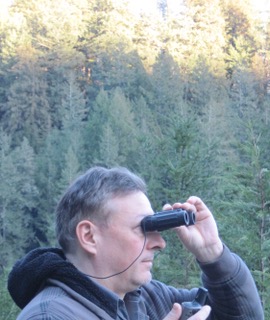
Mapper of the Month: Steve All (USA)
19.01.2017 - Marc Gemis
Who are you?
I am Steve All. In OSM I am stevea and in our wiki I am Stevea. I grew up in San Diego and live in Santa Cruz, California USA since age 17, coming here to attend the University of California and fell in love with the place: starting a business, buying a house, raising a son through the local schools and my alma mater, now he is getting his PhD. I double-majored in Computer Science (Artificial Intelligence) and Applied Linguistics and became a software professional. I am a former employee of Apple and Adobe and work with various local software companies, improving quality as a Software Quality Engineer, Project Manager or Director of Software Quality. I love to hike and bike and am blessed with many beautiful local landscapes to enjoy these pursuits, including wonderful oceanside rides and deep wilderness hiking and camping. I have been fascinated with maps and geography back to age six when my grandfather sat with me and a world atlas, showing me The Old Country, the city where I was born and the bay we lived near in Southern California. He taught me a way to “fly” while looking at a map, to visualize the real world and a map together, synthesizing both experience and imagination. I think everybody can do this, though some things (say, perceiving 3D topographic contour lines as hills and valleys) take practice. “Flying with maps” still kind of thrills me, even today.
When and how did you discover OpenStreetMap?
In early 2009, a few places in my small city resonated with the trend of “hacker spaces,” where like-minded people gathered with high-speed Internet and incubator/small-startup software companies. Having worked at one of these on the top floor across the street from one such place ten years previous, and with the vibrant University nearby and Silicon Valley a short drive away, I thought “it’s about time!” A flyer on the outside read “Learn How to Map” and I went inside to an OSM Mapping Party, hosted by people from a now-defunct mapping startup. As I began to understand OSM as a volunteer project, or maybe especially because of this, I was instantly all over it!
Volunteering in OSM is very important to me: like helping out at a soup kitchen or contributing to a Wikipedia article, it feels great to give back to a wider community in a way that allows me to share my local knowledge, even as I sharpen my own technical, management and other skills. OSM’s crowd-sourcing and open data democratize mapping in a fresh way. Maybe it took until the 21st century for the technology and a good spirit of sharing to merge, but now with OSM, anybody can learn to map and anybody who needs a decent map can have one or make one!
What do you map? Is there any difference with your early days?
At first, I was keen on completely mapping my little city, my university and my small county. So I did, with great zeal, walking our downtown main streets while scribbling into a notepad every business, bench, wastebasket, tree, fire hydrant, drinking fountain and so on. I coordinated a local landuse import now in its third generation of updated official government data. This turned into http://bestofosm.org/#best-of-us-santa-cruz bestowing upon Santa Cruz a Gold Star Award, one of just a few places in North America to receive such an accolade — where Santa Cruz is said to have “nearly perfect landuse.” Working with staff, faculty, interns, contractors and students at the University of California Santa Cruz and its Transportation Department, OSM became the campus map and for web and smart-phone apps. This partly followed from my [Tasking Manager “cake map”] (http://mapcraft.nanodesu.ru/pie/191) allowing multiple people to select a slice to complete, one college and sub-region of the university at a time. While the cake isn’t “all green” yet, it is perhaps 85% - 90% complete. We created legally-compliant wheelchair routes, bicycle and equestrian trails, denoted in OSM which Upper Campus Ecological Area hiking trails were open and closed, imported exact shapefile boundaries of Nature Reserves, named buildings correctly, coordinated a new addressing scheme, put in parking lot details and much more. Not only does the university agree OSM is better than their old maps, one aspect we love is networked data which can be updated in nearly real-time. This allows the campus map to become a fabric shared by everybody, usable and improvable for creative and academic purposes, an especially appealing feature for a university. Indeed, professors have invited me to participate in classes where OSM is a star of the curriculum, one in computer science, another in environmental studies.

Actively hiking and biking, I mapped (or saw was mapped) every park trail in the county I could. It became a sort of game, filling in the missing pieces: hiking, biking, mapping all together, like a puzzle to finish — now that is fun! I crafted and proposed to our Regional Transportation Commission a local bicycle network numbering protocol called CycleNet modeled on San Francisco’s and our national United States Bicycle Route System (USBRS). I entered into OSM both CycleNet and a good portion of the USBRS, an OSM WikiProject I coordinate. I spoke on this topic at SOTM-US in Washington, DC in 2014.
As OSM documents USBRS’ robust growth, I saw USA rail infrastructure and passenger rail routes as incomplete: in 2007-8 OSM imported a vast amount of road and rail data from our federal government, but rail data were rough, needing comprehensive review. As we dialog on talk-us pages Rail Westerly, Rail USA about the world’s largest rail network, we saw this was (and is!) a vast amount of work. The OpenRailwayMap renderer, by some very dedicated people in Germany, is an excellent tool to visualize and document our progress. I found a “triple relation” model used in Germany might be simplified into a “double relation” method in the USA (one relation for track infrastructure, another for passenger routes) and documented this in our wiki. Soon after, better USA rail mapping was off and running! We partly use a “divide and conquer” strategy at a state level, with California/Railroads a wiki for others in the USA to use as a model (if desired), though simpler ones are better wiki seed templates. Wikis and color-coded tables we place into these are often a great way to snapshot a “status report” of how complete are structured tasks in a WikiProject, such as railway route and passenger train relations. It’s neat to see growth, be part of the collaboration with other OSM volunteers in my state and elsewhere and watch as tables “go green” from yellow or red. It might seem slow in real-time, especially compared with the speed of various map renderings, which have a speed of their own, yet the public process of “how OSM grows up as a map” has the natural pace that it has. I like the way the map grew in 2009, I like the way the map grows now. These are a bit different from each other: now, OSM is more grown-up in many good ways.

How do you map? Do you make surveys? Are you an armchair mapper?
Both. I map by making surveys with my trusty Garmin GPSmap 60CSx, a notepad and pencil as well as armchair mapping, so, it depends. If it is local and I can hike or bike it, I might trace GPX into OSM, sometimes with satellite/aerial imagery as an additional guide — if the path isn’t obscured by trees: 2/3 of my county has trees as landcover. A bit different are circumstances when my most important OSM endeavor is assuring that an import is of the utmost quality as it makes its way into our map. For example, a fellow OSM volunteer (friend/hiking buddy, lives a couple of counties away) wanted to do a major landuse import of Monterey County, next-door to both of us. These were state-government GIS data, and needed months of careful massaging and slow-and-steady importing: at over 100 miles (161 km) end-to-end, Monterey County is almost like a small country! Eventually, as a two-person team, both of us finished our tasks, then mapnik took weeks to eventually render at all zoom levels. While there is always more to do to improve our map, I think Monterey County is now rather pretty and a certain level of precise, as it has recent, high-quality, carefully-vetted and curated official landuse data. One square of Earth’s checkerboard at a time, OSM maps the whole world, better and better every day, thank you very much!
Important to “how I map” is to update various wikis with progress, even if this means creating them (or “status update tables” within them) from scratch. There is a lightweight markup language to do this, learning it is only a small hill to climb. I do lots of copy-paste-editing in tables so it goes pretty fast. Perhaps better for beginners is a newer and more interactive way to edit wiki text, much more directly and intuitively. I find it a bit cumbersome to enter tables with this newer editor, but it’s nice to have a choice, so now you can “ease into editing wiki” at your own pace in at least a couple of different ways.
Starting local, watching the feedback in the map, reading our wiki, listening to and collaborating with fellow OSM volunteers, especially when local, trying out new tools as we grow: OSM mapping is an organic process. Some beginners grow to intermediate and advanced skill levels, others prefer to “keep it light and easy,” perhaps adding things they see in the real world and maybe as they change and evolve over time. It’s all good: no mapping task that positively contributes to OSM is too small.
Also, I enjoy visiting someplace I’ve never been (on vacation, friends or family…), check out what is missing in OSM, exploring when I arrive, then improving OSM afterwards if I can. It is so satisfying to watch the map “blossom” with recent additions and improvements. Sometimes OSM moves a bit more “batch it all up at once,” though a lot of the time OSM stays interactive with itself, listening while growing. It moves in fits and spurts, it is human and organic, it works.
Which tools do you use?
I use GPS, an old-fashioned notepad and pencil, JOSM as my primary editor (I use iD as well) and both read and contribute to a good deal of wiki. I use OSM Inspector from Geofabrik Tools to find errors in the map, and thanks to a recent Weekly OSM post I added this as a JOSM layer to try out. I pay attention to JOSM’s Validator plugin, doing my best to correct Errors and improve Warnings it flags. Especially helpful is OverpassTurbo to make queries of the map, as it is as flexible as OSM’s plastic tagging scheme with its well-structured API (the Overpass QL language). An easy tool is the Notes feature which many use, novices and experts alike. I like to fix local Notes other people leave as I might know an answer about them — that is one of OSM’s best tools in action: “local personal knowledge.” MapRoulette is also fun and I’ve started my own tasks there to improve the map. I follow and occasionally contribute to the talk-us pages, learning a lot from the wisdom shared and questions asked there. Some of the most important “tools” I use are politeness, an open-hearted and open-minded attitude that there is always more to learn, along with a good spirit of collaboration with my fellow mapping volunteers. OSM is a big project, we all have much to learn and contribute. So, I’d say “listening skills” are a major tool in this project: the more I listen, the more I learn.
How do you conduct your surveys?
I hike or bike with friends, my trusty GPS and a notepad. The great outdoors and new, under-mapped frontiers await! Of course, if I notice a shop or café has changed as I pass by in an urban area, I’ll update it in the map, either with my mobile device there and then, or with a note for when I get back to my big-screen desktop JOSM session. Diligent, local updating is something we might all strive to do more of in our respective communities, as map data do go stale. We all benefit from updates, so I update.
Where do you map?
I originally mapped locally, quickly extending from my little city and university to my county. Then, as I grew up in and often visit family and recreate in other parts of my state, I began to map more of California. I discovered many OSM mappers around me, including firefighters, newspaper reporters, government GIS employees, university transportation staff and faculty, visual artists, professional cartographers, software developers, hikers, bikers and many others from vast walks of life. I have “friended” dozens of people via OSM’s missive system, with hundreds of messages exchanged with people all over the world. People are so kind: they share with me, I share with them: OSM is a wonderful “we.”
Bike trips, camping trips, day hikes, visits to friends in other cities, Burning Man, vacations: all of these turn into less-local mapping as I hone OSM skills with different editors, tools, techniques and fresh knowledge of newer tagging from reading our many and well-written wiki pages, not to mention listening to how other people do things. I seem to find room to simultaneously grow the map and grow my skills, a satisfying sweet spot.
Going local, then regional/statewide was a stepping-stone to going national and even worldwide with bicycle route efforts in the USBRS and United States Rail WikiProjects. A bicycle mapping enthusiast and OSM volunteer from Italy who consults/coordinates with Germany’s and Switzerland’s national and international bicycle mapping efforts contacted me to say that he would soon be in my little California city to visit a branch of his family. We had a nice chat at my dining room table with a big-screen OSM session that lasted several hours — of course, tea, snacks and wine included! We both learned a great deal from each other that afternoon, and OSM’s bicycle routes continue to improve worldwide.
Summertime only months ago, there were some epic large fires not too far from me in Central California that burned hundreds of square miles over many weeks. Rare for the USA, and I’m glad I was part of it, I joined a HOT group to add swimming pools and human structures (houses, barns) to a sparsely-populated area the fires were threatening, using new imagery making its way into OSM with careful human eyeballs providing fresh map editing. 30 to 40 people quickly jumped in and became eyes and cartographers to aid helicopter water-bucket pilots. Within 36 hours we completed this substantial HOT task, and while I don’t know it first-hand, I believe we likely helped save a great deal of property and perhaps even lives (including a good amount of livestock), as the fire was extinguished soon after our HOT task was completed. As HOT got to 100% completion, I phoned the press line at CalFire headquarters and an OSM friend of mine, a firefighter two counties away I collaborated with years before, quickly got the news as I reported this, Citizen Mapper Volunteer at the finish line! If nothing else it was a fantastic example drill of what we can achieve, so that’s a lot right there. Cool!
What is your biggest achievement as mapper?
It was an honor (and a bit exciting) to be a part of the fire HOT task noted above. I believe “channelling good intentions” of the USBRS into OSM and continuing growth as high-quality statewide and local bicycle route mapping improves was and is good work. One USA mapper (banned from OSM, quite rare) made a mess of national bicycle routes in 2011-2012, and it brought together a few years, great patience and counsel from a super-volunteer in Adventure Cycling Association (and its Board of Directors), AASHTO (USA’s national highway and bicycle route numbering organization), OSM-US’ Board and other OSM volunteers as USBRS untangled and better developed in OSM. 11,243 miles (18094 km) of national bicycle routes in the USA are projected to grow to 50,000 miles (~80000 km), that’s pretty huge. The USBRS WikiProject has reached a certain maturity, with good wiki, process and data. As other OSM volunteers tackle new routes state by state, We Can Do This Together! We do: so far, so good. I think USBRS in OSM is very close to 100% correct, as it grows nicely.
The Gold Star Award from BestOfOSM.org was nice, but that wasn’t only me: I stand shoulder-to-shoulder with many other OSM volunteers.
Rail USA seems in earlier stages of improvement, with California/Railroads data about “late alpha,” while much of the USA sees tremendous progress (correction, improvement and development) during the last couple of years. This is an ongoing achievement: it challenges OSM-US with its scope and complexity. We continue to “get there,” even as the phrase “the map is never done” rings true about USA Rail as much as it does anywhere.
Why do you map? What motivates you?
Quality, available geographic data seem a “basic right:” everybody ought to have access to a decent map of anywhere, for whatever good reason. The explosion of wonderful things from OSM is big: many people now have maps they need where they didn’t before, as the data can or do improve constantly. It gives me a great feeling knowing that my contributions are used by all sorts of people, so I do my best to offer quality working examples (of data, code, process, documentation, structure, collaboration…) as others contribute more. It’s fascinating to marvel at such organic growth and an honor to participate.
As I met OSM volunteers who became hiking buddies and especially after attending my first OSM-US conference, I began to realize how much it is the human/people aspect to the project that I find so rewarding. There are dazzlingly talented people who contribute to OSM. I enjoy meeting them, both in person at conferences, and “in the map.” Also, the sheer fun of the geometry, the challenges of untangling and “getting it right” and “seeing it blossom” remain both thrilling and rewarding, even after 7+ years. I expect I’ll contribute to OSM for many more years: you can OSM at almost any age, from any walk of life and from virtually any place on our wonderful planet. A couple years ago, I was contacted by a professor emerita who needed a map of sub-Saharan Africa circa middle-20th-century for a book she was writing, so I helped her right down to the provincial boundaries of Zimbabwe. She recently published this map with OSM data and proper attribution. She said “I got exactly the map I wanted, how often in life do we get exactly what we want?!” With OSM, you can and you do. Now, THAT is motivating!
In short, “I’m human, I map.”
What is the most difficult part of mapping? (e.g. learning editors, tags? finding tags for items specific for your area or interests? Staying motivated? Repeating boring things? )
I agree all of those have their difficult aspects. Learning and improving in OSM is like climbing hills: you gain perspective as you go farther, as your view gets higher and the capabilities you can achieve get more polished. And yes, “Practice Makes Perfect.” I don’t mean (only) the technical aspects of understanding how to use a tool or tag, I include the people aspect: learning to see things from somebody else’s perspective, especially as you might be collaborating with someone from a very different part of the world. Learning that our map is shared and how to contribute towards consensus while listening and learning is so important. That can be difficult too, as people tend to naturally assume that their way is the right way. Sometimes it is, sometimes it isn’t, sometimes you have something to contribute that others listen to and it becomes part of things, sometimes not. OSM is an ongoing, long-term dialog among many people, and our listening skills are paramount in such a lofty endeavor as a worldwide, crowd-sourced, widely shared map.
What are your mapping plans for the near future?
Whew, where to begin? To manage my OSM, lest it consume my every moment! Seriously, ongoing updates to the few imports and mapping I participate in (around my local community), USBRS bicycle routes and rail infrastructure/passenger routes are a lot. I’ve bitten off much, yet manage to chew. “Stand aside and watch more” sounds about right. Recently, I was asked to join the Los Angeles Buildings Import task, a huge undertaking in Southern California. As much as I wanted to pitch in, I said no. That’s just the way it goes, sometimes. I endeavor to keep my User page updated with my current tasks, and while our Diary feature isn’t something I use often, it’s a great way to utter a blurb about what you are up to. Again, wikis are great at keeping status updated, whether it is a specific project to polish up map data, or what any particular volunteer is working on “now;” wikis are integral to OSM.
Do you have contact with other mappers?
Yes, quite a few! Dozens, maybe hundreds. I welcome more. Contact me using OSM missive if you wish. I answer with a polite and friendly tone and am told my earnest passion for OSM shines through loud and clear.
Do you use OpenStreetMap yourself? How?
Oh, YEAH! One way I find absolutely awesome is that every few weeks fresh updates arrive on talk-us of Garmin-downloadable OSM images (which I share as a peer, from this side of the Atlantic). That is fantastic as all I do is copy to a microSD chip/card, pop it into my Garmin GPS, and recent edits to OSM are now in the palm of my hand when I hike into wooded wilderness with no WiFi or cell, yet good-enough with high-trees GPS satellites up in orbit. Yeah! This closes the feedback loop for lots of us: use the map, improve the map, use an improved map and up and up it grows! And that is merely a beginning: there are many new ways “better” data (improving every day) merit their way into our great shared OSM fabric. On smartphones, with wireless/mobile and some pretty/clever mapping apps that better leverage OSM data, I think we have only begun to scratch the surface of OSM’s deep potential.
Do you do anything else than mapping that is related to OpenStreetMap?
I attend and speak at OSM conferences when invited to do so, an important part of the “building community” aspect of the project. Besides, in addition to being highly rewarding with technical and often artistically beautiful aspects of our project, these are truly fun! Again, it is the people in OSM I find so rewarding.
To conclude, is there anything else you want to mention?
OpenStreetMap is an amazing project, it is practically a worldwide movement empowering people to learn more about our environment, communities, infrastructure, architecture and more, while positively contributing with others doing the same. Much like anything else in life, what you put in, you get back, and maybe even “then some.” Thank you for inviting me to share my experiences with OSM. Now, shall we go out and map? Yes!