Road completion project
Project lead: Joost Schouppe, Ben Abelshausen & Jonathan Beliën
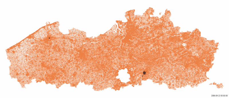 Red is government data, the less red, the more complete OSM becomes.
We’re called OpenSTREETMap for a reason: we have an excellent road network. With turn restrictions and lane navigation, hiking paths and cycle lanes. But there are still some basic mistakes here and there. We aim to correct these mistakes by using open government datasets to verify and detect missing data. Meanwhile, we’ll improve government data too, and offer you a guaranteed minimum quality.
Crowdsourcing, Open Data and Machine Learning
As we are crowdsourcers, every mistake that our crowd sees will be corrected. But some changes aren’t very visible. For example, a new road with just a few houses, without connections. A name change of a road, or a misspelled road name. Or a road that was mapped back when aerial imagery was much lower quality.
Governments around the world are embracing open data, so more and more open road datasets are becoming available. Artificial vision can now easily generate a basic road network when new imagery is released. We want to use that data to improve our map - and why not, to improve those datasets themselves too.
As a community, we want to build the tools to make sure that any correction in the official open data road sets is made visible to the mapping community as quickly and as accurately as possible. We started with the Flemish road dataset, but there are similar datasets in the other regions and around the world. So we’ve built something that is easily scalable to any dataset of road centerlines worldwide.
 The evolution of mapping roads in Brussels. Green: slow roads. Grey: mapped roads. Black: roads being worked on that month
Trust
OpenStreetMap grows in a chaotic way. In some places, data quality is amazing. In others, the map is still very basic. More importantly: the map comes without any guarantees. We want to build trust in the data by offering a simple guarantee: OSM is just as complete as the government dataset. With the tool we built, you can check at any time how many road segments the government has and OpenStreetMap does not. Hopefully, that will make OSM in Belgium usable in even more cases because there is a metric of completeness.
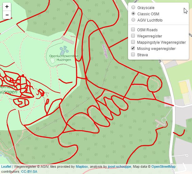 A sample of missing ‘slow’ roads
You can follow up on the number of missing roads here.
Current status
- Comparison process is running every week for Flanders and Brussels
- Comparison process is run manually for Wallonia
- We are mapping in MapRoulette, to get started go to this instructions page
- You can follow up on the number of missing roads here.
- Digitaal Vlaanderen has processed our feedback for Flanders. While our mappers used the government data, they spotted 561 cases where the official data was probably wrong. This resulted in corrections on their end in 90% of the cases.
Project key events
- Exploration of Wegenregister as a source, with mapping layers and downloadable GPX files (diary entry)
- The other way around: validating Wegenregister with OSM in Antwerp (diary entry)
- Set up a Task in the Belgian tasking manager; in the town of Halle as an example.
- Added a wiki page with a project overview
- Presented the project at FOSS4G.
- Started a first Maproulette task to map missing roads
- Presented at State of the Map 2018 (video and slides) and AIV Trefdag 2017
- Created a prototype at Open Summer of Code 2018
- The production version is maintained at the OSMBE github page. This was made possible by an OpenStreetMap Foundation microgrant 2020, which allowed our Board member Jonathan Beliën to invest the necessary time to build the tool. During set-up, we added Flanders, Brussels and Wallonia. Since then, Luxemburg, Kosovo and the Netherlands were added.
- During 2021 we worked with Digitaal Vlaanderen to help them use our feedback. We sent them 561 cases where the official data was probably wrong. This resulted in corrections on their end in 90% of the cases.